Complete Catalog (8164 items)

Shaw, The History and Antiquities of Staffordshire.

8131. Shaw, Rev. Stebbing.

The History and Antiquities of Staffordshire. Complete Set of two Volumes (all published/fully restored). With an original Plan of Wolverhampton, A large map of Staffordshire, Engravings of Boscobel House, The Pedigree of Turton, Etchings of Kings Bromley, Pipe Ridware House, Lichfield, Site of Blythbury Priory, Mavesyn Ridware, Cathedral of Lichfield, View of Freeford, etc. etc. Volume I – Containing the Ancient and Modern History of Thirty Parishes in the Hundred of Offlow, arranged Geographically, with an Appendix of the most curious Charters &c. Illustrated with sixty-two copper plates and a copious Index / Volume II – Part1 (all published) – Containing the Prefatory Introduction, commencing with a Series of Original Letters from Plot’s time to the present; General and Natural History &c. Ancient and Modern History of the remaining Parishes in the Hundred of Offlow and the Whole of Seisdon, arranged Geographically with an Appendix of curious Charters and other additions and Corrections &c. Illustrated with fifty copper plates and a copious Index. Compiled from the Manuscripts of Huntbach, Loxdale, Bishop Lyttelton, and other Collections of Dr.Wilkes, the Rev. T.Reilde. Including Erdeswicke’s Survey of the County and the approved parts of Dr. Plot’s Natural History. The whole brought down to the present time. Interspersed with Pedigrees and Anecdotes of Families, Observations on Agriculture, Commerce, Mines and Manufactories and illustrated with a very full and correct new map of the County, “Agri Staffordiensis Icon” and numerous other plates.

London, J.Nichols and Son, 1798-1801. Large-Folio. Volume I: Folded Map of Staffordshire by W.Faden, Portrait of Rev. Shaw (detached), XXIV, (2), 125, XXXVIII, 434, 38 pages / Volume II, Part I: A Plan of Wolverhampton, XXXII, 290, 20 pages. With a double-page plan, a large, folded county map (coloured), 82 engraved plates, numerous vignettes within the text and 3 folded pedigree – tables. Modern Hardcover. Exceptionally restored. This work is difficult to handle if not in a sturdy binding ! Original Edition in professionally rebound halfleather with gilt lettering on spine and extra-strong boards, suited for this heavy set. This masterpiece of underestimated english local history is of great interest because of its fold out maps and numerous large folio etchings.

EUR 3.500,-- 

Show details   Add to cart

Hodges, Cork and County Cork in the Twentieth Century / Contemporary Biographies

8144. Hodges, Rev. Richard J. / Pike, W.T.

Cork and County Cork in the Twentieth Century / Contemporary Biographies. / [History of Big Houses, Town Houses and Country Estates in Cork, County Cork, North Cork, East Cork & West Cork with original Photographs of Houses and Portraits as well as Biographies of the Men and their Families who lived in these Houses] / [Half-Leather-Version – Limited Edition Reprint]. Edited by W. T. Pike.

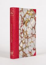
Limited Edition Reprint of the First and only Edition by Pike in 1911. [Skibbereen (County Cork)], Inanna Rare Books / Inanna Reprint Series, 2022. 4° (24,5 cm wide x 33,5 cm high). 319 pages with hundreds of photographs and including an Index to Biographies and Illustrations. Hardcover / Half-Leather with marbled-paper-covered boards in protective Collector’s Mylar. [Important Information: This special limited edition has a special feature which makes each volume of this reprint unique: Each version of the book is bound by hand by a craft-bookbindery and the colour of the leather and endpapers, as well as the marbled-paper-covered boards, are always different / This means the interior is always the same while the look of the binding can differ from the image attached to this description]. One of 350 copies of the Half-Leather-version of a limited edition, republished by Inanna Rare Books Ltd. / This high-quality reprint, hand-bound and hand-numbered, includes hundreds of photographs of grand houses in the irish countryside from South Cork to North Cork, from East Cork to West Cork. The stories of the houses are not only accompanied by photographs of now mostly vanished or derelict homes, the images also show the original state of homes which are now restructured etc. The second part of the publication offers an abundance of historical biographies of local irish Nobility (Meade family, O’Callaghan, Browne, Kelly etc.), Gentry and Clergy and general owners of Country Houses etc. [Pike’s New Century Series].

EUR 475,-- 

Show details   Add to cart

Philip Luckombe, The Compleat Irish Traveller [Luxury Reprint with all of Charles Smith's Illustrations of 18th century Ireland (Munster / Kerry / Waterford) in separate Folder for Framing]

8146. [Luckombe, Philip / Smith, Charles].

Luxury Reprint of “The Compleat Irish Traveller” [With high quality Reproductions of the 31 original Plates of detailed Maps of County Cork in the 18th century, County Kerry in the 18th century and Waterford in the 18th century, as well as some of the earliest engravings of Irish Towns here for the first time reproduced as beautiful Artworks for framing and housed in a special, handmade Folder. The publication was just recently enlarged with a detailed, Topographical Index (July 2023)]. Complete Title: “The Compleat Irish Traveller, containing A general Description of the most Noted Cities, Towns, Seats, Buildings, Loughs &c. in the Kingdom of Ireland, Interspersed with Observations on the Manners, Customs, Antiquities, Curiosities and Natural History of that Country. With Elegant Copper Plates”. [With 31 original Plates after Charles Smith, including Frontispiece, this Reprint / Facsimile is the result of 10 years of research and purchase of three (3) original versions of the First Edition from the year 1788. The first Editions known to Inanna Rare Books all had different quantities of Plates and Maps included. This Reprint by Inanna Rare Books has been produced from an extremely clean version of the original and shows the most complete set of illustrations and XL-Size Maps and Artworks we could find in any of the original editions. The publication shows not only Maps of County Cork, County Kerry and County Waterford but also Views of Irish Cities and Towns in these Counties of the Province of Munster and besides the wonderful Historical Plan of Cork City this set also includes the very rare Plan of the “Grand Canal from Dublin to the River Shannon” (see detailed list of all the illustrations present at the end of this description)].

Luxury Limited-Edition-Reprint of the First Edition by Luckombe in 1788. Two Volumes plus extra Folder with 31 Plates reprinted as Artworks for framing. Skibbereen (County Cork), Inanna Rare Books Publishing, 1788. Octavo (13.5 cm x 21 cm). Pagination: Volume I: Frontispiece, engraved Titlepage, XXX, 189 pages plus recently published Index (July, 2023) / Volume II: Engraved Titlepage, 263 pages plus recently published Index (July, 2023). Plus large, bespoke made Folder with thirtyone (31) Reproductions of the Maps, Plans and Illustrations which usually were folded inside this publication and now for the first time have been liberated from the book and were published as the beautiful works of art they are. Textvolume: Volume I and II of the text bound in one beautiful half-leather-volume with gilt lettering on spine, bound in the style of the 18th century / Illustrations-Folder with 31 reprinted illustrations of Towns and Maps of Ireland but mainly of Munster, bound in bespoke made half-cloth with paper-covered boards and pasted Reprint of the original titlepage. Excellent, new condition. One of only 300 printed. [Inanna Rare Books – Reprint & Facsimile – Series].

EUR 2.480,-- 

Show details   Add to cart

Page: 1 2 ... 79 80 81 82
: