


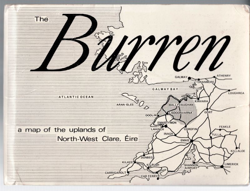
Robinson, The Burren - A Map of the Uplands of North-West Claire (Éire)
The Burren – A Map of the Uplands of North-West Claire (Éire)
Arainn, T.D.Robinson, 1977. Folio Size – Folded. Softcover. Very good condition with only minor signs of wear. Extremely Rare !
“Tim Robinson’s “Burren map”, often called a “two-inch map,” is celebrated for its deep coverage of topography, including karst limestone, 450+ cashels, ringforts, megalithic tombs, and early churches”.
Robinson utilized a “deep mapping” approach, combining artistic sensibility with extensive historical, ecological, and topographical research to create a profound understanding of the landscape.
He considered the Burren a “vast memorial to bygone cultures” and documented it extensively in his cartographic work.
His work on the West of Ireland, including the Burren and Aran Islands, garnered him positions as a Fellow at Magdalen College, Cambridge and recognition by Aosdána.
Robinson’s work is considered essential for navigating and understanding the intricate, “contradictory” nature of the Burren’s limestone landscape. (Wikipedia)
- Keywords: Catalogue Irish History Five – Local Irish History · Catalogue Irish History Four – Irish Postwar History & Administration · County Clare · Irish Geology · Irish History – Rare · Irish Local History
- Language: English
- Inventory Number: 32489AB
EUR 160,--
We ship per DHL Express
Contact
Inanna Rare Books Ltd.
Woodley House
Castletownshend Road
P81 D262 Skibbereen, County Cork
Ireland
Phone: ++353 - (0) 87 - 102 5412
E-Mail: info@inannararebooks.com
Internet: https://www.inannararebooks.com
Online Bookshop specialized in rare
and secondhand books.
Newsletter and E-Catalogue Sign Up
Payment Options


© 2026 Inanna Rare Books Ltd. | Powered by HESCOM-Software
Follow Us

