Maps (41 items)

Nathaniel Hooke - The Roman History, From the Building of Rome to the Ruin of the Commonwealth

35. Hooke, Nathaniel.

The Roman History, From the Building of Rome to the Ruin of the Commonwealth [with the printed Dedication to Alexander Pope]. Illustrated with 17 folding Maps, 4 Fontispieces and 11 other Plates [32 copper-engravings in total].

The Fourth Edition. Four Volumes (complete set with all maps and plates). London, Printed for J. and R. Tonson; Hawkins and T.Longman, 1766 – 1771. Quarto (27 cm x 22 cm). Collation: Volume I: Frontispiece, XLVI, XLVI, 634 pages with 10 plates and 3 maps / Volume II: Frontispiece, XXXII, XXXII, 668 pages with 8 maps / Volume III: Frontispiece, VI, 694 pages with 5 maps / Volume IV: Frontispiece, VII, 464 pages plus 76 unnumbered pages of a General Index and 1 plate and 1 map. Hardcover / Original 18th-century leather with gilt lettering and labels on spine. Interior of this set with all maps and illustrations in excellent, very clean condition. The boards of the bindings with abrasions and some bumping but overall very firm. Some stronger peeling of the leather on board of Volume I, Only three pages with minor tears. The large map of Northern Africa (Palestine, Egypt and Libya) with a minor tear. The stunning maps and plates in timeless beauty. Highly underestimated work, in the shadow of Gibbon but with meticulous detail in presenting the geographical impact of the Roman Conquest. From the library of Daniel Conner (Connerville / Manch House), with his Exlibris / Bookplate to pastedown.

EUR 3.500,-- 

Show details   Add to cart

[Wilson, The Universal Gazetteer: or a Description of the several Empires,

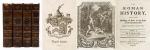
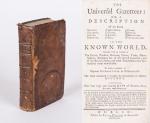
36. [Wilson, Peter / Martin, Benjamin].

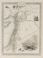
The Universal Gazetteer [Very Rare Dublin Edition] : or a Description of the several Empires, Kingdoms, States, Provinces, Countries, Cities, Towns, Seas, Lakes, Rivers, Mountains, Volcanos &c. in the Known World. Together with an Account of The Extent, produce, Revenue, Forces, Trade, Manufacturer, Religions &c. of the several Countries and of the Battles, Sieges and other Transactions that have sendered them remarkable. To which is prefixed a copious Introduction to Geography. The whole calculated to explain the Occurences in Modern History. Illustrated with four large and accurate Maps of Europe, Asia, Africa and America (only the Map of Asia is present: “New & Correct Map of Asia – Drawn from the latest and best Authorities by J. Gibson”). The Second Edition, in which several necessary Corrections and Material Additions have been made; the Geography of Ireland has been revised and enlarged; about four hundred entire new Articles have been added, chiefly relative to North America and Ireland, none of which are contained in the London Impression, and comprising in the whole, many thousand Places more than any other Gazzetteer; Whereby it is rendered the largest, cheapest, and most compleat Work of the Kind extant.

Dublin, Printed for Peter Wilson in Dame-Street, 1759. Small Octavo. XXXVIII, (1), 512 unnumbered pages (collation complete) with only the folded Map on Asia present and the other three maps missing. Including 6 pages of “Books, printed for and sold by Peter Wilson, in Dame-Street”. Original Hardcover (full calf on five raised bands with original spinelabel intact). Half a page in chapter “M” torn out. Faint dampstain throughout. Otherwise in very good condition. Binding rubbed and bumped on the corners but absolutely firm and tight. Minor traces of foxing and staining only. Name of preowner in 17th or 18th century ink on endpaper: “Daniel Eugene MacNamara”. Very rare Dublin Edition of this publication with a full-page recommendation of the famous Lexicographer Benjamin Martin.

EUR 1.200,-- 

Show details   Add to cart

Barrow, Voyage dans la partie meridionale de l'Afrique

40. Barrow, John.

Voyage dans la partie meridionale de l’Afrique; fait dans les années 1797 et 1798; par John Barrow, Ex-Secretaire de Lord Macartney…Contenant des observations sur la géologie, la géographie, l’histoire naturelle de ce continent, et une esquisse du caractère physique et moral des diverses races d’habitans qui environnent l’Etablissement du Cap de Bonne-Espérance. / Accompagné: Nouveau Voyage dans la partie méridionale de l’Afrique; Où l’on examine quelle est l’importance du Cap de Bonne-Espérance pour les différentes puissances de l’Europe, considéré comme station militaire et navale; comme boulevart du commerce et de la domination des Anglais dans l’Inde; comme centre des établissemens pour la pêche de la baleine dans les mers Australes; comme acquisition territoriale, et comme entrepôt commercial en tems de paix. Accompagné d’une description statistique de la colonie rédigée sur les documens les plus hautentiques, enrichi de huit belles cartes, contenat celle de la Côte d’Afrique depuis la baie de la Table jusqu’a la baie de Saldanha, des cartes de la baie de Pletenberg, d’Algola, de Mossel et de False bay; du plan militaire de la péninsule du Cap, et de ceux de la baie de la Table et du Knisna. (2 Volumes).

First French Edition. 4 Volumes [complete set of two works with 2 Volumes each]. Paris, Dentu, 1801-1806. 35.5 cm x 55.8 cm. Collation: complete. Pagination: Volume I: XVI, 403, (1) pages / Volume II: 326, (2) pages including Errata-leaf / Volume III: X, 310 pages / Volume IV: 312 pages. Original contemporary red calf with gilt lettering and ornament to lacquer-polished-spine. The Volumes are numbered consecutively, even though these are two separate works. Excellent condition of the binding and interior of this important publication with very minor signs of foxing only ! All the maps in wonderful condition ! First french edition of “Travels into the Interior of Southern Africa” (Barrow’s journey with Lord Macartney in 1797 to the Cape of Good Hope) plus two further Volumes which describe the second journey in 1801 / 1802 to Saldanha Bay [Saldanhabaai] with an early image of Robben Island. The survey of the Dutch colonies was not only a seminal work on South Africa but the beautifully engraved, large folding map of South Africa was a turning point of african cartography and geographical illustration.

EUR 1.480,-- 

Show details   Add to cart

Page: 1 2 3 4 5
: