English History (156 items)

[Saunders, Rider's British Merlin: For the Year of our Lord 1799.

101. [Saunders, Richard] Rider, Cardanus.

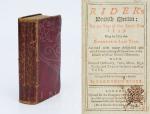
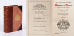
Rider’s British Merlin: For the Year of our Lord 1799. Being the Third after Bissextile or Leap-Year. Adorned with many delightful and useful Verities, fitting all Capacities in the Islands of Great Britain’s Monarchy. With notes of Husbandry, Fairs, Marts, High Roads and Tables for many necessary uses. Compiled for the Country’s Benefit by Cardanus Rider. [With: “The Arms of the Peers, Peeresses &c. of England, Scotland & Ireland the Insignia of the Different Orders of Knighthood with the Baronets of Great Britain and the Dates of their Creations” [With: “Heraldry in Miniature” / Including a small section to the end of the publication with “British Governments in America and the West-Indies with Upper Canada – Lower Canada – Cape Breton – Virgin Island – Montserrat – Grenada – Jamaica – Leeward Islands – Barbados [Barbadoes]” etc.]. [ With a section on “Peers, Peeresses and Bishops of Ireland – That are Not Peers of England”].

London, Printed for the Company of Stationers, 1799. Slim-Octavo (9,5 cm x 16 cm). Collation complete with parts of the book interleaved: 60, XXXVI, [122 + 4 misbound planches with coats of arms, pagination incorrect but all plates available that are called for], plus 321 pages [House of Peers of Great Britain with misprinted pagination to the beginning of the 321 pages]. Original Hardcover / 18th century or early 19th century red leather. Stronger rubbed but firm and intact binding. Interior with tear to page 15/16, some minor foxing and browning only, some writing to interleaved pages in a child’s hand. All plates with Heraldic Bearings, Coat of Arms, Emblemata, Badges etc. included. Here the rare 1799 publication with over 500 examples of Heraldry of Ireland, Scotland and England. Includes Irish Earls, Irish Barons, Irish Archbishops, Irish Viscounts, etc. [Coat of Arms of Fingal, Glandore, Lisburne, Winterton, Arran, Barrymore, Marq. Donegall, Clanricarde, Fife, Lowth, Upper Ossory etc. etc.]

EUR 380,-- 

Show details   Add to cart

Cary's New Itinerary: Or an Accurate Delineation of the Great Roads, Both Direct and Cross throughout England and Wales: With Many of the Principal Roads in Scotland.

107. Cary, John.

Cary’s New Itinerary: Or an Accurate Delineation of the Great Roads, Both Direct and Cross throughout England and Wales: With Many of the Principal Roads in Scotland. From an Actual Admeasurement by John Cary: Made by Command of his Majesty’s Postmaster General for official purposes: Under the Direction and Inspection of Thomas Hasker Esq., Surveyor and Superintendant of the Mail Coaches. [Including an advertising for Cary’s New Celestial and Terrestrial Globes (with Illustrations of Globes)]. [Subtitle:] This work shows the immediate Route from the Metropolis [London] to all parts of England and Wales: And from Town to Town in every direction, distinguishing also the Cities, Market, Borough and Corporate Towns: And those at which the Assizes are held and gives the time of the Mails, Arrival and Departure from each, Describes the Line of the Navigable Canals and the Course of the Rivers passed over, The Number of Houses and Inhabitants contained in each Town, And those Inns which supply Post Horses and Carriages. Also The Inn’s throughout the Metropolis [London] from which the Mail and Stagecoaches go, their time of departure & the Route they seveerally take. The Noblemen and Gentlemen’s Seats situate near the Roads, A List of the Packet Boats and their time of sailing. Copious Indexes. Maps of the Lot Wight Environs of London, Bath, Brighton, Margate & Cheltenham & a Large Map of England and Wales peculiarly adapted to the Work. – [An Advertisement juxtaposed to the titlepage reads: “This Edition contains the Routes to upwards of Nine Thousand Places, which have never been given in any work of a similar Description; being a complete Directory to every Parish situate out of the Line of the Direct and Cross Roads throughout England and Wales”].

Seventh Edition, with Improvements [complete with all maps as called for]. London, Printed for J. Cary, 1817. Octavo. Pagination: [1], 647 pages plus 7 maps / Detailed pagination see here: [1], Title, Large Folding Map, [121], 6 folded Maps, [526] pages. Modern, recent Hardcover / Very decorative half-leather with marbled-paper-covered boards. Gilt lettering on new sppine-label. New endpapers. Protective Mylar. Only the large folding map with a inor tear (one part of the map deliberately bound separate (geniously folding out to meet th erest of the map). Interior text and maps all in excellent, unusually clean condition !!

EUR 480,-- 

Show details   Add to cart

Page: 1 2 ... 8 9 10 11 12 13 14 15 16
: