West Cork Rare BookfairINANNA MODERNWest Cork Reading Holidays
We ship per DHL Express

We ship per DHL Express

Books with vintage Maps

Payne, A New and Complete System of Universal Geography; Describing Asia, Africa

Payne, John / Hardie, James / Provenance I: Signature of J.J. Westervelt [Jacobus James Westervelt (1755 – 1826) – Schraalenberg and Provenance II: Charles Sydney Clark (1925) presented this set to Johnson Free Public Library at Hackensack, New Jersey].

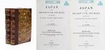
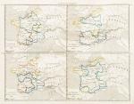
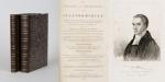
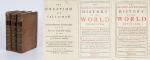
A New and Complete System of Universal Geography [Complete with all 20 maps / illustrations] ; Describing Asia, Africa, Europe and America; with their Subdivisions of Republics, States, Empires and Kingdoms : The Extent, Boundaries and Remarkable Appearances of each Country; Cities, Towns and Curiosities of Nature and Art. Also giving a general account of The Fossil and Vegetable Productions [with hand-coloured plates] of the Earth. The History of Man, In all Climates, Regions and Conditions; Customs, Manners, Laws, Governments and Religions: The State of Arts, Sciences, Commerce, Manufactures and Knowledge. Sketches of the Ancient and Modern History of each Nation and People to the present time. To which is added, A View of Astronomy, As connected with Geography; Of the Planetary System to which the Earth belongs; And of the Universe in General. With a copious Index annexed to each Volume. Being a Large and Comprehensive Abridgement of Universal Geography. By John Payne. With additions, corrections and Improvements from the latest and best authors by James Hardie – Author of “The Principles of Latin Grammar”, “The American Remembrancer” and “Universal Tablet of Memory” &c. In Four Volumes.

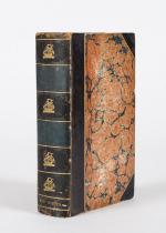
First Abridged Edition. Volumes I [Asia] and II [Africa] (of IV). New York, Printed for and Sold by John Low, Book-Seller at The Shakespeare – Head, No.332 Water-Street, 1798 – 1799. Octavo – Edition. Pagination: Volume I [Asia]: Folded Frontispiece (Map of the World), XLVIII, 518 pages plus 10 unnumbered pages of an Index and one additional page with Directions for the Bookbinder for placing the maps and illustrations as well as Errata. Volume I includes all 10 Maps / Engravings as called for / Volume II [Africa]: Folded Frontispiece (Map of Africa), 578 pages plus 12 unnumbered pages of an Index plus one additional page with Directions for the Bookbinder for placing the maps and illustrations as well as Errata. Volume II includes all 10 Maps / Engravings as called for. Hardcover / Modern Library – Binding with the original 18th century – work bound in. Former library copy of Bergen County Historical Society (cancelled) and Johnson Free Public Library in Hackensack, New Jersey, with a very boring, modern library binding and library cards applied to the endpapers only, leaving the bookblock with text and maps and illustrations entirely untouched from any library-signs. Very good condition with some signs of external wear.

EUR 2.480,-- 

Show details   Add to cart

Johannes Justus Rein, Japan nach Reisen und Studien im Auftrage der Königlich Preussischen Regierung dargestellt

Rein, J.J. [Johannes Justus] / [Provenienz / Provenance: Max von Baden / Bibliothek Schloss Salem].

Japan nach Reisen und Studien im Auftrage der Königlich Preussischen Regierung dargestellt von J.J. Rein [Johannes Justus Rein], Professor der Geographie in Marburg [an der Lahn]. Erster Band: Natur und Volk des Mikadoreiches. Mit 5 Lichtdruckbildern [Photographien], 12 Holzschnitten, 3 Lithographischen Tafeln und 2 Karten. / Zweiter Band: Land- und Forstwirthschaft, Industrie und Handel. Mit zum Theil farbigen Tafeln, 20 Holzschnitten im Text und 3 Kaertchen.

Erste Ausgabe [First Edition]. Two Volumes. Leipzig, Verlag von Wilhelm Engelmann, 1881 – 1886. Gross-Oktav. Band I: XII, [1], 630 Seiten mit allen Abbildungen und insbesondere der Original-Photographie von Nagasaki aber ohne die “Orographish-hydrographische Karte [Japans]” am Schluss des Bandes. / Band II: XII, 678 Seiten mit den drei Falt-Karten von Japan am Schluss des Bandes . Hardcover / Original 19th century half-leather with gilt lettering and ornament to spine. / Originale Verlags-Leinenbaende. Ehemalige Exemplare der “Bibliothek Salem” und ehemaliges “Eigenthum des Prinzen Wilhelm”, mit zwei dezenten Bibliotheksschildchen der Bibliothek Salem im Innendeckel und dem Stempel des Prinzen Max von Baden [″MB” mit Krone] auf den Titelseiten. Very good condition with only minor signs of wear and only the two folded Maps missing / Sehr guter Zustand des seltenen Werks und mit nur wenigen Stockfleckchen, wie ueblich auf den Rueckseiten des Photo-papiers und Abklatsch auf den Seiten verso. Aus dem Vorwort: “Saemtliche Illustrationen dieses Buchs sind Originale – Bonn, im September 1886 – Der Verfasser”.

EUR 2.480,-- 

Show details   Add to cart

Shaw, The History and Antiquities of Staffordshire.

Shaw, Rev. Stebbing.

The History and Antiquities of Staffordshire. Complete Set of two Volumes (all published/fully restored). With an original Plan of Wolverhampton, A large map of Staffordshire, Engravings of Boscobel House, The Pedigree of Turton, Etchings of Kings Bromley, Pipe Ridware House, Lichfield, Site of Blythbury Priory, Mavesyn Ridware, Cathedral of Lichfield, View of Freeford, etc. etc. Volume I – Containing the Ancient and Modern History of Thirty Parishes in the Hundred of Offlow, arranged Geographically, with an Appendix of the most curious Charters &c. Illustrated with sixty-two copper plates and a copious Index / Volume II – Part1 (all published) – Containing the Prefatory Introduction, commencing with a Series of Original Letters from Plot’s time to the present; General and Natural History &c. Ancient and Modern History of the remaining Parishes in the Hundred of Offlow and the Whole of Seisdon, arranged Geographically with an Appendix of curious Charters and other additions and Corrections &c. Illustrated with fifty copper plates and a copious Index. Compiled from the Manuscripts of Huntbach, Loxdale, Bishop Lyttelton, and other Collections of Dr.Wilkes, the Rev. T.Reilde. Including Erdeswicke’s Survey of the County and the approved parts of Dr. Plot’s Natural History. The whole brought down to the present time. Interspersed with Pedigrees and Anecdotes of Families, Observations on Agriculture, Commerce, Mines and Manufactories and illustrated with a very full and correct new map of the County, “Agri Staffordiensis Icon” and numerous other plates.

London, J.Nichols and Son, 1798-1801. Large-Folio. Volume I: Folded Map of Staffordshire by W.Faden, Portrait of Rev. Shaw (detached), XXIV, (2), 125, XXXVIII, 434, 38 pages / Volume II, Part I: A Plan of Wolverhampton, XXXII, 290, 20 pages. With a double-page plan, a large, folded county map (coloured), 82 engraved plates, numerous vignettes within the text and 3 folded pedigree – tables. Modern Hardcover. Exceptionally restored. This work is difficult to handle if not in a sturdy binding ! Original Edition in professionally rebound halfleather with gilt lettering on spine and extra-strong boards, suited for this heavy set. This masterpiece of underestimated english local history is of great interest because of its fold out maps and numerous large folio etchings.

EUR 1.400,-- 

Show details   Add to cart

Shuckford, The Sacred and Profane History of the World connected

Shuckford, Samuel.

The Sacred and Profane History of the World connected, Frome the Creation of the World to the Dissolution of the Assyrian Empire at the Death of Sardanapalus, and to the Declension of the Kingdoms of Judah and Israel, under the Reigns of Ahaz and Pekah. [Together with: “The Creation and Fall of Man” – “A Supplemental Discourse to the Preface of the First Volume of the Sacred and Prophane History of the World connected”].

The Third Edition. 3 Volumes (of 4). London, Printed for J. and R. Tonson and S. Draper in the Strand, 1753. Octavo. LXIV,366, [10], LV, 461, [10], CXXXII, 295, [16] pages. Each Volume with its own Index. Includes two folded maps in Volume One: First Map: “A Plan of the present Chanels [sic] of the Rivers Hiddekel or Tigris and Euphrates exhibiting the Site of Moses Garden and River of Eden” / Second Map: “The Situation of the Land & Garden of Eden together with the Rivers of Paradise as they are imagined to have been Situate by some Writers who thought that the Garden of Eden was planted in that which was afterwards called the Holy Land”. Original Hardcover / 18th century full leather with new spinelabels. All three Volumes are now in protective Mylar. with dustjacket. All Volumes with some damage to spine but all still firm and holding. Overall some faint staining and foxing only at very few locations because of the excellent paper-quality of this publication. From the library of Daniel Conner (Connerville / Manch House), with his Exlibris / Bookplate to pastedown.

EUR 480,-- 

Show details   Add to cart

Page: 1 2 3
: