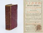
[Saunders, Richard] Rider, Cardanus.
Rider’s British Merlin: For the Year of our Lord 1799. Being the Third after Bissextile or Leap-Year. Adorned with many delightful and useful Verities, fitting all Capacities in the Islands of Great Britain’s Monarchy. With notes of Husbandry, Fairs, Marts, High Roads and Tables for many necessary uses. Compiled for the Country’s Benefit by Cardanus Rider. [With: “The Arms of the Peers, Peeresses &c. of England, Scotland & Ireland the Insignia of the Different Orders of Knighthood with the Baronets of Great Britain and the Dates of their Creations” [With: “Heraldry in Miniature” / Including a small section to the end of the publication with “British Governments in America and the West-Indies with Upper Canada – Lower Canada – Cape Breton – Virgin Island – Montserrat – Grenada – Jamaica – Leeward Islands – Barbados [Barbadoes]” etc.]. [ With a section on “Peers, Peeresses and Bishops of Ireland – That are Not Peers of England”].
London, Printed for the Company of Stationers, 1799. Slim-Octavo (9,5 cm x 16 cm). Collation complete with parts of the book interleaved: 60, XXXVI, [122 + 4 misbound planches with coats of arms, pagination incorrect but all plates available that are called for], plus 321 pages [House of Peers of Great Britain with misprinted pagination to the beginning of the 321 pages]. Original Hardcover / 18th century or early 19th century red leather. Stronger rubbed but firm and intact binding. Interior with tear to page 15/16, some minor foxing and browning only, some writing to interleaved pages in a child’s hand. All plates with Heraldic Bearings, Coat of Arms, Emblemata, Badges etc. included. Here the rare 1799 publication with over 500 examples of Heraldry of Ireland, Scotland and England. Includes Irish Earls, Irish Barons, Irish Archbishops, Irish Viscounts, etc. [Coat of Arms of Fingal, Glandore, Lisburne, Winterton, Arran, Barrymore, Marq. Donegall, Clanricarde, Fife, Lowth, Upper Ossory etc. etc.]


![Chearnley / Smith / Luckombe - [Luckombe, The West Prospect of the Nave, Choir & Steeple of Buttevant Abbey with St.Mary's Chappel [sic].](/images/thumbnails/900076AG.jpg)

![[Daniel O'Connell] Patrick Power, The Courts Martial of 1798-1799.](/images/thumbnails/31241AB.jpg)
![[O'Nolan Family History] Nolan, O'Nolan - The History of A People.](/images/thumbnails/31672AB.jpg)
![O'Rahilly, Táin bó Cúalnge: from the Book of Leinster. [Together with: Táin bó Cúalnge - Recension I].](/images/thumbnails/29846AB.jpg)
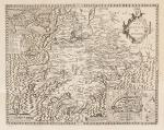
![Jean-Denis Barbié du Bocage - Tableau de la Grande-Bretagne, De L'Irlande et des Possessions Angloises dans les quatre parties du Monde. [Large Paper Copy / Better Paper Copy / Exemplaire de Luxe]](/images/thumbnails/28935AB.jpg)

![[St.Columba]. St. Columba's / Record of the League of St.Columba](/images/thumbnails/28747AB.jpg)

![[Trevor, Edward / Kilmainhaim Gaol (Jail)] / [Anonymous (attributed to Sanders, Robert) - THE ROMAN HISTORY IN A SERIES OF LETTERS FROM A NOBLEMAN TO HIS SON](/images/thumbnails/31237AB.jpg)

![Urban, The Gentleman's Magazine [London Gazette] and Historical Chronicle for the Year MDCCXCVIII [1798]](/images/thumbnails/29378AB.jpg)
![Vallancey, Collectanea de Rebus Hibernicis [Five Volume - Set]](/images/thumbnails/31502AB.jpg)
![Edward Wakefield, An Account Of Ireland, Statistical And Political [Volume Two (of 2)].](/images/thumbnails/31329AB.jpg)
![Sir James Ware / Ancient Irish Histories. The Works of Spencer, Campion, Hanmer, and Marleburrough [sic] [Henry of Marlborough]](/images/thumbnails/29905AB.jpg)
![[William Livingston Webb, Lettres sur les Anglois et les François et sur les Voiages [Voyages].](/images/thumbnails/29730AB.jpg)